| 777 |
| |
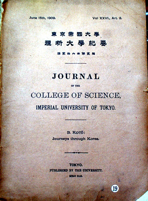
Journeys through Korea./1909
A geographic sketch of Korea in 1903, Journal of the College of Science, Imperial University Tokyo, Japan. Vol. XXVI, Article 2., n. d. (1910); 4to (26,5 x 21 cm); pp. 207(1)
|
Koto, Bundjiro
|
Imperial University of Tokyo, |
English
|
|
|
| 775 |
| |
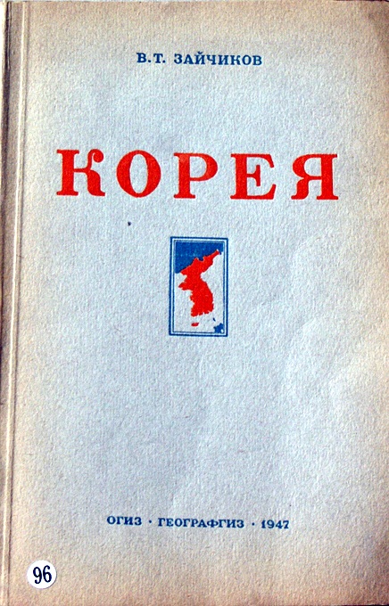
KOREA( in Russian)/1947
8 vo.first edition. 227 pages with b/w photographs and illustrations. Rare source on Geographical information of Korea.
|
V.T.Zaichikov |
National Publishing House of Geaographical Literature,Moscow |
Others
|
|
|
| 774 |
| |
SAN KOKF TSOU RAN TO SETS ou apercu general des TROIS ROYAUMES.
/1832
First Edition. 4to - over 9¾" - 12" tall. Volume I: Text: 8 vo. vi, [1], 288 pp. / Volume II: 4to. Plates & Maps, 5 colour folding maps + 2 plates, subscribers leaf for the Athenaeum bound before title, translated from original Japanes-Chinese............. Oriental Translation Fund of Great Britain and Ireland. 1832, 1832. Illustrated Survey of the Three Kingdoms Complete with Five Folding, Hand-Colored Maps KLAPROTH, Julius von, [translator]. San kokf tsou ran to sets, ou apercu general des trois royaumes . ouvrage accompagne de cinq cartes. Paris: Printed for the Oriental Translation Fund of Great Britain and Ireland, 1832. First Western edition. Octavo (9 3/4 x 6 1/4 inches; 248 x 158 mm.). [2], vi, [2], 288 pp. With a large quarto album (12 9/16 x 9 3/4 inches; 320 x 248 mm.) complete with a printed title-page and seven engraved plates, five of which are hand-colored folding maps. Contemporary quarter brown morocco over marbled papers, spine stamped and lettered in gilt in compartments, top edges gilt. Album with marbled endpapers, octavo with uncut fore-edge. Corners bumped on both; light browning to octavo. Minor splits along folds of some of the maps. Overall a very good copy with clean, bright maps. First written in Japanese and rendered in Chinese characters in 1785, this is the first Western edition of Rinsifee's San kokf tsou ran to set, or "Illustrated Survey of Three Kingdoms," edited and translated into French by German Orientalist Julius von Klaproth. Although certainly an able interpretation and impressive work of scholarship, this edition is most extraordinary for its large quarto album, which includes five magnificent hand-colored, engraved maps: "Carte de Iles Inhabites ou Mou Nin Sima"; "Carte de L'Ile de Ieso"; "Carte des Trois Royaumes"; "Carte des Iles Riou Kiou"; and "Carte des Huit Provinces du Tchao Sian." All of the maps are folding; the largest folds out to 21 1/4 x 28 1/2 inches, or 540 x 725 mm. Published in Edo, Japan at the end of the eighteenth-century, San kokf tsou ran to sets was written by Hayashi Shihei (1738-1793), a Japanese military stragetist, explorer, and writer also known as Rinsifee. In this book, Rinisfee recounts an exploratory survey of the geography of the regions that were then the frontiers of Japan, including Korea, Hokkaido, and the Ryukyu Islands, and provides descriptions of the inhabitants, including the Ainu. Anticipating European infiltration of Japan, in later works Rinisfee would advocate for improved defenses along Japanese frontiers and a stronger maritime presence. German Orientalist and explorer Julius von Klaproth (1783-1835) published several dozen translations during his lifetime but is probably best known for his 1823 work Asia polyglotta nebst Sprachatlas, one of the first linguistic surveys of Oriental languages. Cordier 2946.
|
Hayashi, Shihei(林子平,日本人1738-1793 ) KLAPROTH, Heinrich J. translator(German Orientalist1783-1835) |
Printed for the Oriental Translation Fund of Great Britain and Ireland,Paris |
French
|
|
|
|
|
|
|
| 661 |
| |
SAN KOKF TSOU RAN TO SETS ou apercu general des TROIS ROYAUMES./1832
Paris Printed for the Oriental Translation Fund of Great Britain and Ireland. 1832, 1832. Illustrated Survey of the Three Kingdoms Complete with Five Folding, Hand-Colored Maps KLAPROTH, Julius von, [translator]. San kokf tsou ran to sets, ou apercu general des trois royaumes . ouvrage accompagne de cinq cartes. Paris: Printed for the Oriental Translation Fund of Great Britain and Ireland, 1832. First Western edition. Octavo (9 3/4 x 6 1/4 inches; 248 x 158 mm.). [2], vi, [2], 288 pp. With a large quarto album (12 9/16 x 9 3/4 inches; 320 x 248 mm.) complete with a printed title-page and seven engraved plates, five of which are hand-colored folding maps. Contemporary quarter brown morocco over marbled papers, spine stamped and lettered in gilt in compartments, top edges gilt. Album with marbled endpapers, octavo with uncut fore-edge. Corners bumped on both; light browning to octavo. Minor splits along folds of some of the maps. Overall a very good copy with clean, bright maps. First written in Japanese and rendered in Chinese characters in 1785, this is the first Western edition of Rinsifee's San kokf tsou ran to set, or "Illustrated Survey of Three Kingdoms," edited and translated into French by German Orientalist Julius von Klaproth. Although certainly an able interpretation and impressive work of scholarship, this edition is most extraordinary for its large quarto album, which includes five magnificent hand-colored, engraved maps: "Carte de Iles Inhabites ou Mou Nin Sima"; "Carte de L'Ile de Ieso"; "Carte des Trois Royaumes"; "Carte des Iles Riou Kiou"; and "Carte des Huit Provinces du Tchao Sian." All of the maps are folding; the largest folds out to 21 1/4 x 28 1/2 inches, or 540 x 725 mm. Published in Edo, Japan at the end of the eighteenth-century, San kokf tsou ran to sets was written by Hayashi Shihei (1738-1793), a Japanese military stragetist, explorer, and writer also known as Rinsifee. In this book, Rinisfee recounts an exploratory survey of the geography of the regions that were then the frontiers of Japan, including Korea, Hokkaido, and the Ryukyu Islands, and provides descriptions of the inhabitants, including the Ainu. Anticipating European infiltration of Japan, in later works Rinisfee would advocate for improved defenses along Japanese frontiers and a stronger maritime presence. German Orientalist and explorer Julius von Klaproth (1783-1835) published several dozen translations during his lifetime but is probably best known for his 1823 work Asia polyglotta nebst Sprachatlas, one of the first linguistic surveys of Oriental languages. Cordier 2946.
|
Hayashi, Shihei(林子平,日本人) KLAPROTH, Heinrich J. translator(German Orientalist ) |
Printed for the Oriental Translation Fund of Great Britain and Ireland,Paris |
French
|
|
|
|
| 519 |
| |
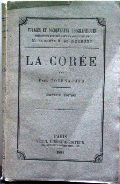
LA COREE/1894
paperback, 170 pages plus a map.General overview of Korea at the
end of 19th century.
|
Paul Tournafond |
Teoui ,Libraire Editeur , Paris |
French
|
|
|
| 477 |
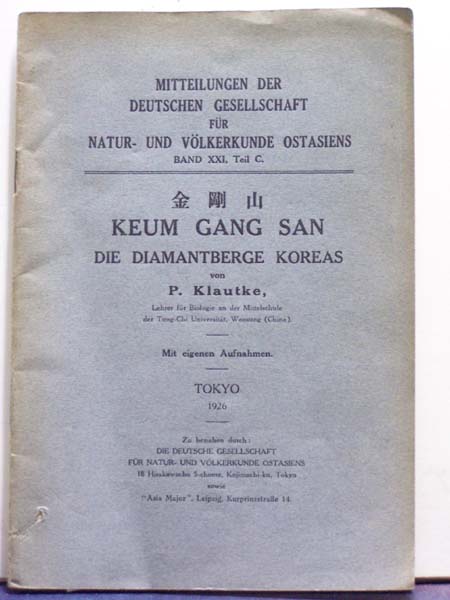
| |
KEUM GANG SAN(Die Diamantberge Koreas)/1926
paperback,60 pages. First and only edition.
Illustrated with numerous b/w photographs.
A General overview of Mt.Diamond in Korea.
|
P.Klautke |
Die Deutsche Gesellschaft fur Natur und Volkerkunde Ostasiens,Tokyo |
German
|
|
|
|
|
|
|
|
| 222 |
| |
Historische Berschryving der REIZEN of Nieuwe en Volkkoome Verzameling (volume 10)/1750
hard cover,365 pages.
An account on Korea and Henry Hamel's(Hamel Hendrik) shipwreck at
the Quelpart(Cheju Island of Korea) from page 1 to 48.
Henry Hamel was a Captain of East India Company.He was a prison
of Korea in 1653-1666 . In 1666 he escaped from Korea to Japan
and returned home and published a book titled A Account of the Shipwreck of
a Dutch Vessel....
A description of Korea and Cheju(Quelpaert or Quelpart) based on observation while captive in Korea.One of the earliest western language books on Korea.
Hamel was shipwrecked on Quelpart island in the middle of the 17th century and was held prisoner in Korea for 13 years.
|
Pieter de Hondt |
Holland |
Others
|
|
|
|
|
|
|
|
|
|
|
| 124 |
| |
Voyage of His Majesty's Ship Alceste to
China,Corea and the Island of Lewchew with an Account of Her Shipwreck /1819
hard cover,339 pages.third edition.
In 1817 The ship Alceste brought Lord Amherst to China to serve as ambassador and to help assuage the differences of opinion that had developed between China and Great Britain pertaining to the China trade. During the course of its voyage the ship was wrecked on a hitherto uncharted reef in the vicinity of Borneo but crew and passengers were eventually rescued. This is the best edition of this work, and the first to include the plate of Fort Maxwell. Also included is the account of a meeting with Bonaparte on St. Helena.
|
John M'Leod ,M.D. |
John Murray,Albermarle-Street,London |
English
|
|
|
| 116 |
| |
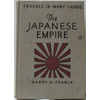
The Japanese Empire/1927
hard cover, 256 pages.
Illustrated with numerous photographs.
Travels in Many Lands Series. Illustrated. A nice description of pre-World War II Japan and Korea.
|
Harry A.Franck |
F.A.Owen Publishing Company,New York |
English
|
|
|
| 98 |
| |
Recent Journeys in Korea/1886
23 pages and fold out color map of Korea at rear. From Proceedings of the Royal Geographical Society May, 1886. Precedes Author's "Life in Corea" (1888).
|
W.H.Carles |
Proceedings of Royal geographical Society,London |
English
|
|
|
|
|
|
|
| 65 |
| |
Place Name Index for KOREA(Chosen)/1943
paperback,63 pages with a large map of Korea.
A Syllabic Table/Guide to the pronunciation of romanized Korean/
Guide to the pronunciation of romanized Japanese/Glossary of Common Japanese and Korean Geographical Terms/English-Korean-Japanese Glossary.
Place name Index to map of Korea in Romanized japanese/Chinese charaters
/Korean alphabet/Romanized Korean.
|
Army Map Service,War Department |
Army Map Service,War Deraptment |
English
|
|
|
[1] |